In this post, we will see how to load
GTFS data into PostgreSQL. GTFS stands for General Transit Feed
Specification (originally, it was called Google Transit Feed
Specification) and allows public transit agencies to publish their
schedules on the web.
The task requires the following steps:
- Download the GTFS data for NYMTA
- Create a database schema for loading the GTFS data
- Load the data on a Postgresql/ PostGIS database
Step 1: Download the GTFS data for NYMTA
We will start with the transit feed for
NYMTA as an example. The first step is getting access to the feed.
This is available at the following site.
We can go ahead and download the data
on our machine. Next step is to import the data into a database,
which we will do in the next step.
Step 2: Create a database and user to load the data
My database of choice is Postgresql and PostGIS, so that is what I
used. The first step is to create the database and enable spatial
extension.
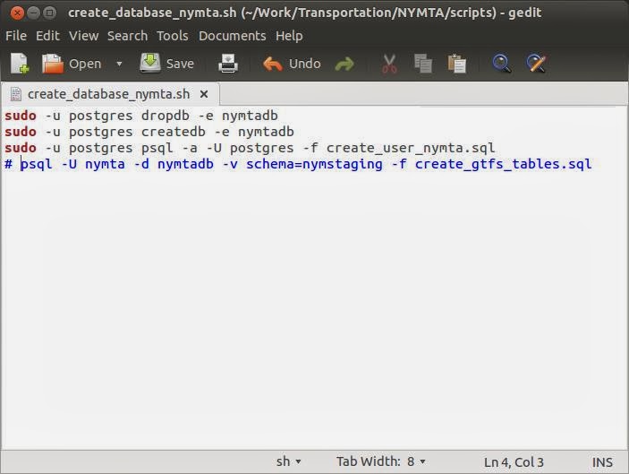
The first script drops a previously existing database, creates the
database and creates the user and schema.
create_database_nymta.sh
sudo -u postgres
dropdb -e nymtadb
sudo -u postgres
createdb -e nymtadb
sudo -u postgres
psql -a -U postgres -f create_user_nymta.sql
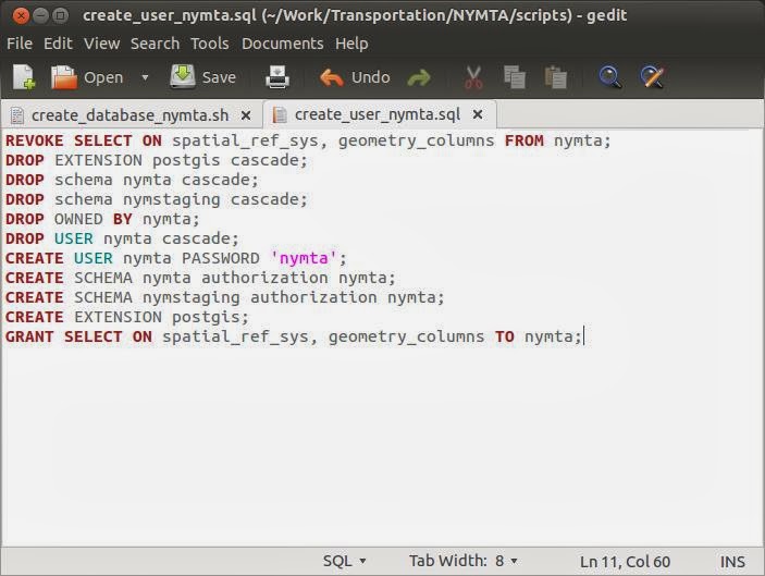
This script calls the following SQL script to create the user and
schemas.
create_user_nymta.sql
REVOKE SELECT ON
spatial_ref_sys, geometry_columns FROM nymta;
DROP EXTENSION
postgis;
DROP schema nymta
cascade;
DROP schema
nymstaging cascade;
DROP OWNED BY nymta;
DROP OWNED BY nymta;
DROP USER nymta;
CREATE USER nymta
PASSWORD 'nymta';
CREATE SCHEMA nymta
authorization nymta;
CREATE SCHEMA
nymstaging authorization nymta;
CREATE EXTENSION
postgis;
GRANT SELECT ON
spatial_ref_sys, geometry_columns TO nymta;
This is how the above script looks in my editor.
To run the script, I typed
$ ./create_database_nymta.sh
Executing the above scripts, we will get prompted for sudo password
once. Here is the console output from the execution on my machine,
for reference.
Step 3: Load GTFS data on RDBMS for easier handling
Next step is to load the GTFS data in
RDBMS for handling. First step is to create a target schema for
storing the data.
Here is my script for creating the
database schema for creating GTFS tables in my staging schema.
create_gtfs_tables.sql
DROP
TABLE GTFS_AGENCY;
DROP
TABLE GTFS_ROUTES;
DROP
TABLE GTFS_STOPS;
DROP
TABLE GTFS_TRIPS;
DROP
TABLE GTFS_STOP_TIMES;
DROP
TABLE GTFS_SHAPES;
DROP
TABLE GTFS_CALENDAR;
DROP
TABLE GTFS_CALENDAR_DATES;
DROP
TABLE GTFS_TRANSFERS;
/*
agency_id,agency_name,agency_url,agency_timezone,agency_lang,agency_phone
MTA
NYCT,MTA New York City Transit,
http://www.mta.info,America/New_York,en,718-330-1234
*/
CREATE
TABLE GTFS_AGENCY
(
agency_id
VARCHAR(10),
agency_name
VARCHAR(50),
agency_url
VARCHAR(100),
agency_timezone
VARCHAR(50),
agency_lang
VARCHAR(2),
agency_phone
VARCHAR(20)
);
/*
routes.txt
route_id,agency_id,route_short_name,route_long_name,route_desc,route_type,route_url,route_color,route_text_color
1,MTA
NYCT,1,Broadway - 7 Avenue Local,"Trains operate between 242 St
in the Bronx and South Ferry in Manhattan, most
times",1,http://www.mta.info/nyct/service/pdf/t1cur.pdf,EE352E,
*/
CREATE
TABLE GTFS_ROUTES
(
route_id
NUMERIC(5),
agency_id
NUMERIC(3),
route_short_name
VARCHAR(10),
route_long_name
VARCHAR(100),
route_desc
VARCHAR(100),
route_type
NUMERIC(3),
route_url
VARCHAR(100),
route_color
VARCHAR(8),
route_text_color
VARCHAR(8)
);
/*
stops.txt
stop_id,stop_code,stop_name,stop_desc,stop_lat,stop_lon,zone_id,stop_url,location_type,parent_station
101,,Van
Cortlandt Park - 242 St,,40.889248,-73.898583,,,1,
*/
CREATE
TABLE GTFS_STOPS
( stop_id
NUMERIC(10),
stop_code
VARCHAR(10),
stop_name
VARCHAR(100),
stop_desc
VARCHAR(100),
stop_lat
NUMERIC(38,8),
stop_lon
NUMERIC(38,8),
zone_id
NUMERIC(5),
stop_url
VARCHAR(100),
location_type
NUMERIC(2),
parent_station
NUMERIC(38)
);
/*
trips.txt
route_id,service_id,trip_id,trip_headsign,direction_id,block_id,shape_id
1,A20130803WKD,A20130803WKD_000800_1..S03R,SOUTH
FERRY,1,,1..S03R
*/
CREATE
TABLE GTFS_TRIPS
(
route_id
NUMERIC(10),
service_id
VARCHAR(10),
trip_id
NUMERIC(10),
trip_headsign
VARCHAR(10),
trip_short_name
VARCHAR(50),
direction_id
NUMERIC(2),
block_id
NUMERIC(10),
shape_id
NUMERIC(10)
);
/*
stop_times.txt
trip_id,arrival_time,departure_time,stop_id,stop_sequence,stop_headsign,pickup_type,drop_off_type,shape_dist_traveled
A20130803WKD_000800_1..S03R,00:08:00,00:08:00,101S,1,,0,0,
*/
CREATE
TABLE GTFS_STOP_TIMES
(
trip_id
NUMERIC(10),
arrival_time
TIMESTAMP,
departure_time
TIMESTAMP,
stop_id
NUMERIC(10),
stop_sequence
NUMERIC(10),
stop_headsign
VARCHAR(30),
pickup_type
VARCHAR(100),
drop_off_type
VARCHAR(100)
);
/*
shapes.txt
shape_id,shape_pt_lat,shape_pt_lon,shape_pt_sequence,shape_dist_traveled
4..N06R,40.668897,-73.932942,0,
*/
CREATE
TABLE GTFS_SHAPES
(
shape_id
NUMERIC(6),
shape_pt_lat
NUMERIC,
shape_pt_lon
NUMERIC,
shape_pt_sequence
NUMERIC(6),
shape_dist_traveled
NUMERIC
);
/*
calendar_dates.txt
service_id,date,exception_type
*/
CREATE
TABLE GTFS_CALENDAR_DATES
(
service_id
VARCHAR(10),
exception_date
DATE,
exception_type
VARCHAR(10)
);
/*
calendar.txt
service_id,monday,tuesday,wednesday,thursday,friday,saturday,sunday,start_date,end_date
A20130803WKD,1,1,1,1,1,0,0,20130803,20141231
*/
CREATE
TABLE GTFS_CALENDAR
(
service_id
VARCHAR(10),
monday
NUMERIC(1),
tuesday
NUMERIC(1),
wednesday
NUMERIC(1),
thursday
NUMERIC(1),
friday
NUMERIC(1),
saturday
NUMERIC(1),
sunday
NUMERIC(1),
start_date
DATE,
end_date
DATE
);
/*
transfers.txt
from_stop_id,to_stop_id,transfer_type,min_transfer_time
101,101,2,180
*/
CREATE
TABLE GTFS_TRANSFERS
(
from_stop_id
NUMERIC(10),
to_stop_id
NUMERIC(10),
transfer_type
NUMERIC(3),
min_transfer_time
NUMERIC(6)
);
To execute the script we need to run the following command on the terminal
$ psql -U nymta -d nymtadb -v schema=nymstaging -f create_gtfs_tables.sql
Executing the same, creates the neccessary tables on our schema.
Next step is to download some spatial data from public sources. We can download the Street centerline data for NYC from the following website.
Opening the data in desktop GIS, we can
see the amount of data available.
Next step, I wanted to do was to load
the GTFS data into the staging schema we just created. For that, we
will use GeoKettle which is a utility for loading data from text
files into PostgreSQL. This I will cover in my next post.


No comments:
Post a Comment